
Land Area Metric Calculator: Hectares, Ares, Gunthas & Bigha Conversion
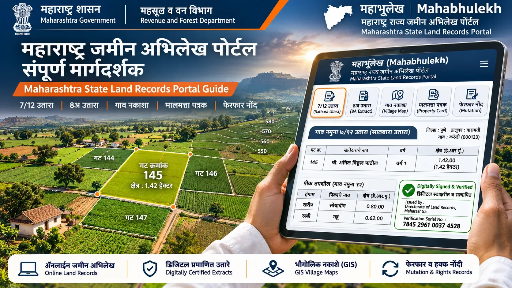
On a 7/12 extract, land area is recorded in Hectares, Ares, and Square Metres (H.R.SqM). One Hectare equals 10,000 square metres (100 Ares or 2.471 Acres). In Maharashtra, 1 Are equals 1 Guntha (1,089 square feet). In Gujarat, 1 Standard Vigha equals 16 Gunthas (17,424 square feet), while in Saurashtra 1 Vigha equals 24 Gunthas.
Statutory Land Record Fact Sheet: Digital 7/12
| Measurement Dimension | Statutory Standard & Metric Formula |
|---|---|
| Official Revenue Unit | Hectare (Ha), Are (R), and Square Metre (Sq.M) under the Standards of Weights and Measures Act |
| 1 Hectare Equivalents | 10,000 sq. metres | 100 Ares | 2.471 Acres | 98.84 Gunthas |
| 1 Guntha / Are Equivalents | 1,089 sq. feet (33 ft × 33 ft) | 121 sq. yards | 101.17 sq. metres |
| 1 Acre Equivalents | 40 Gunthas | 43,560 sq. feet | 4,046.86 sq. metres | 0.4047 Hectares |
| Gujarat Standard Vigha | 16 Gunthas | 17,424 sq. feet | 1,618.74 sq. metres (2.5 Vighas = 1 Acre) |
| Saurashtra Vigha | 24 Gunthas | 26,136 sq. feet | 2,428.11 sq. metres (1.67 Vighas = 1 Acre) |
| Cadastral Demarcation Authority | Taluka Inspector of Land Records (TILR / DILR) under State Land Records Departments |
| Audit & Review Date | 6 November 2026 |
Select Your Immediate Task / नागरिक सेवा निवडा / સેવા પસંદ કરો
Convert your 7/12 extract area into square feet, acres, or regional bighas using our certified metric converter:
{calc_widget}*Statutory Note: Official Maharashtra and Gujarat land revenue registers record area strictly in metric units (Hectares and Ares). Conversions to Gunthas, Acres, and Vighas are mathematical derivatives calculated for transactional and reference convenience.
Standard Metric Land Measurement System
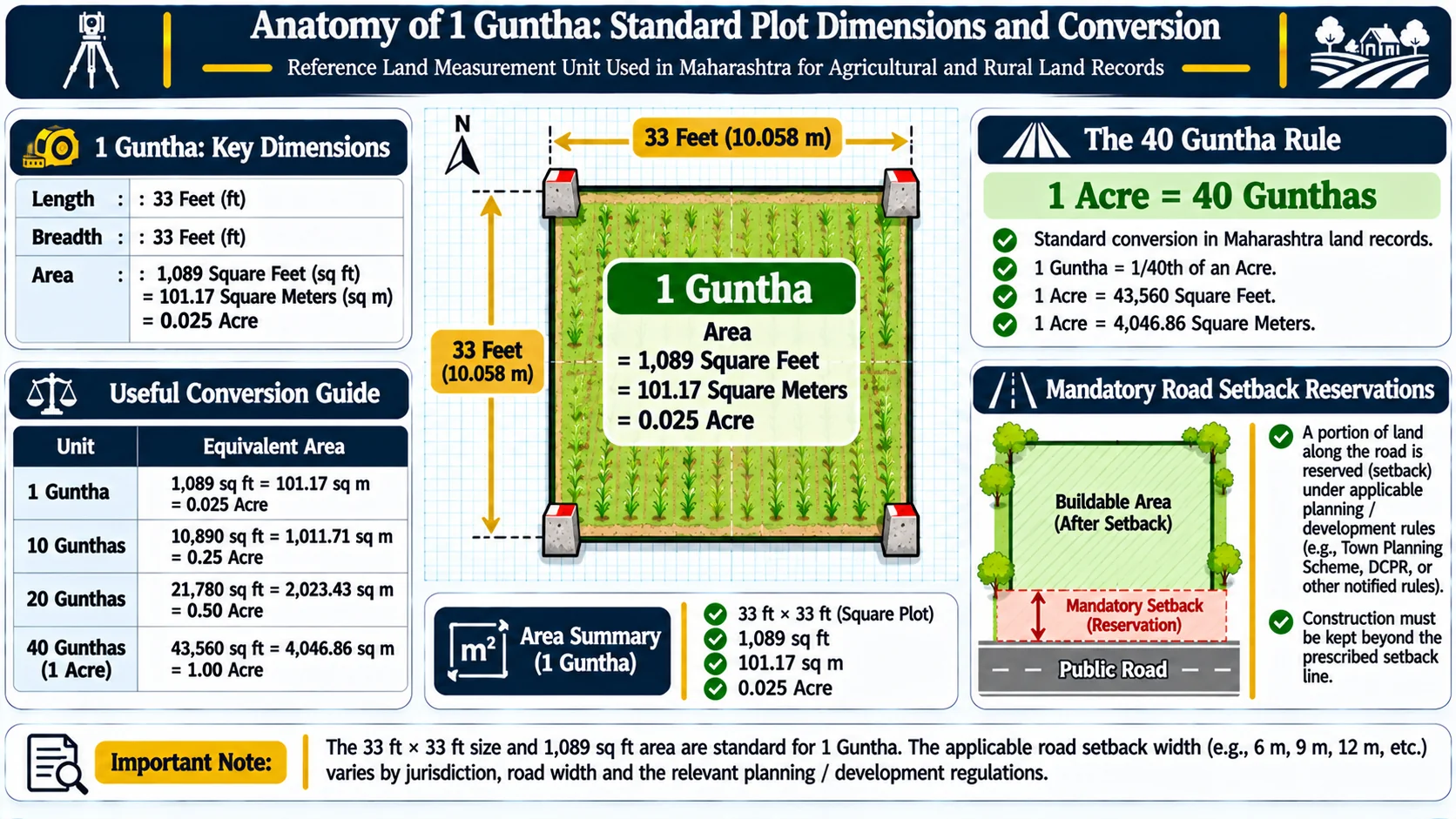
Under the Standards of Weights and Measures Act, 1976 and state land revenue codes, traditional local measurements were replaced by the metric system. The statutory conversion ratios are:
| From Unit | To Metric Square Metres | To Square Feet | To Gunthas / Ares |
|---|---|---|---|
| 1 Hectare | 10,000 sq. m | 107,639 sq. ft | 98.84 Gunthas (100 Ares) |
| 1 Acre | 4,046.86 sq. m | 43,560 sq. ft | 40.00 Gunthas |
| 1 Are (R) | 100 sq. m | 1,076.39 sq. ft | 0.9884 Gunthas (approx 1 Guntha) |
| 1 Guntha | 101.17 sq. m | 1,089 sq. ft (33 × 33 ft) | 1.00 Guntha |
| 1 Gujarat Vigha (Standard) | 1,618.74 sq. m | 17,424 sq. ft | 16.00 Gunthas |
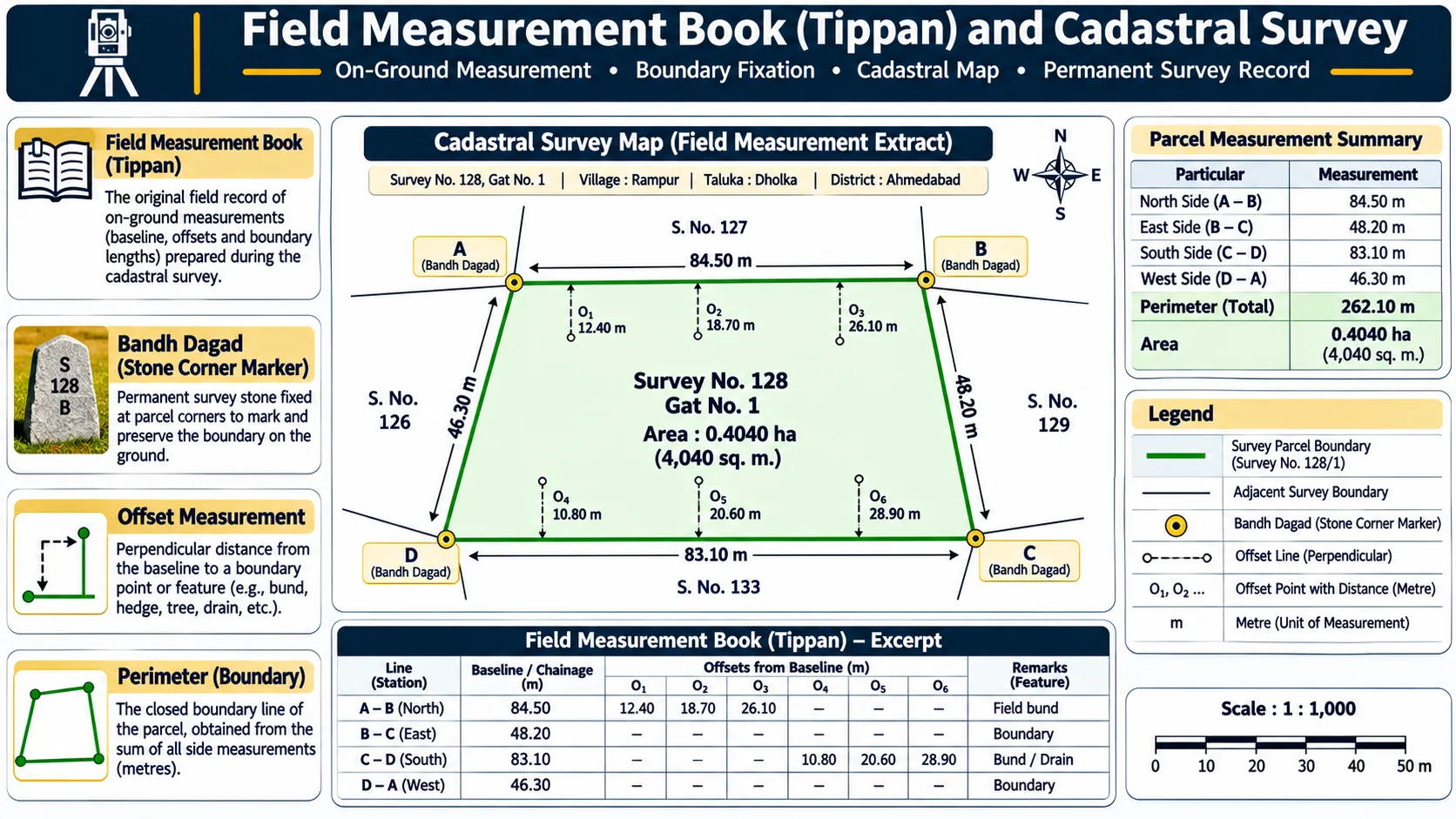
During official boundary demarcations, revenue surveyors attached to the Taluka Inspector of Land Records (TILR / DILR) rely upon the original Tippan (cadastral field book) created during the foundational revenue survey. The Tippan delineates baseline traverse lines, triangulation coordinates, and offset chains that establish the permanent statutory boundaries of each parcel.
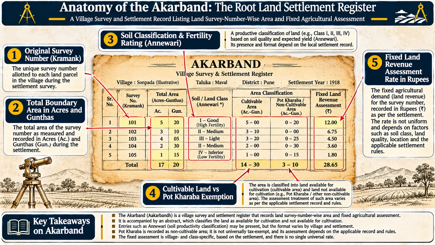
The Akarband serves as the foundational settlement register maintained under Section 105 of the Maharashtra Land Revenue Code, 1966. It records the total surveyed area of each cadastral parcel, classifies the holding into cultivable and uncultivable segments, and fixes the statutory land revenue assessment rate based on soil fertility classifications.
Agricultural Land Partition & Pot-Kharaba Classification
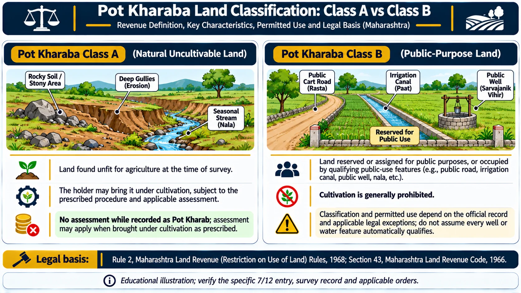
Village Form 7 bifurcates aggregate parcel area into Cultivable Land (Lagwadi Yogya) and Uncultivable Land (Pot-Kharaba):
- Pot-Kharaba Class A: Land rendered uncultivable by natural physical causes (rocks, ravines, slopes, nullahs). This area remains owned by the holder and can be improved, but is exempt from land revenue assessment.
- Pot-Kharaba Class B: Land reserved for public utility purposes (roads, paths, water canals, community tanks, graveyards). No private ownership or commercial construction is permitted on Class B land, and it cannot be alienated.
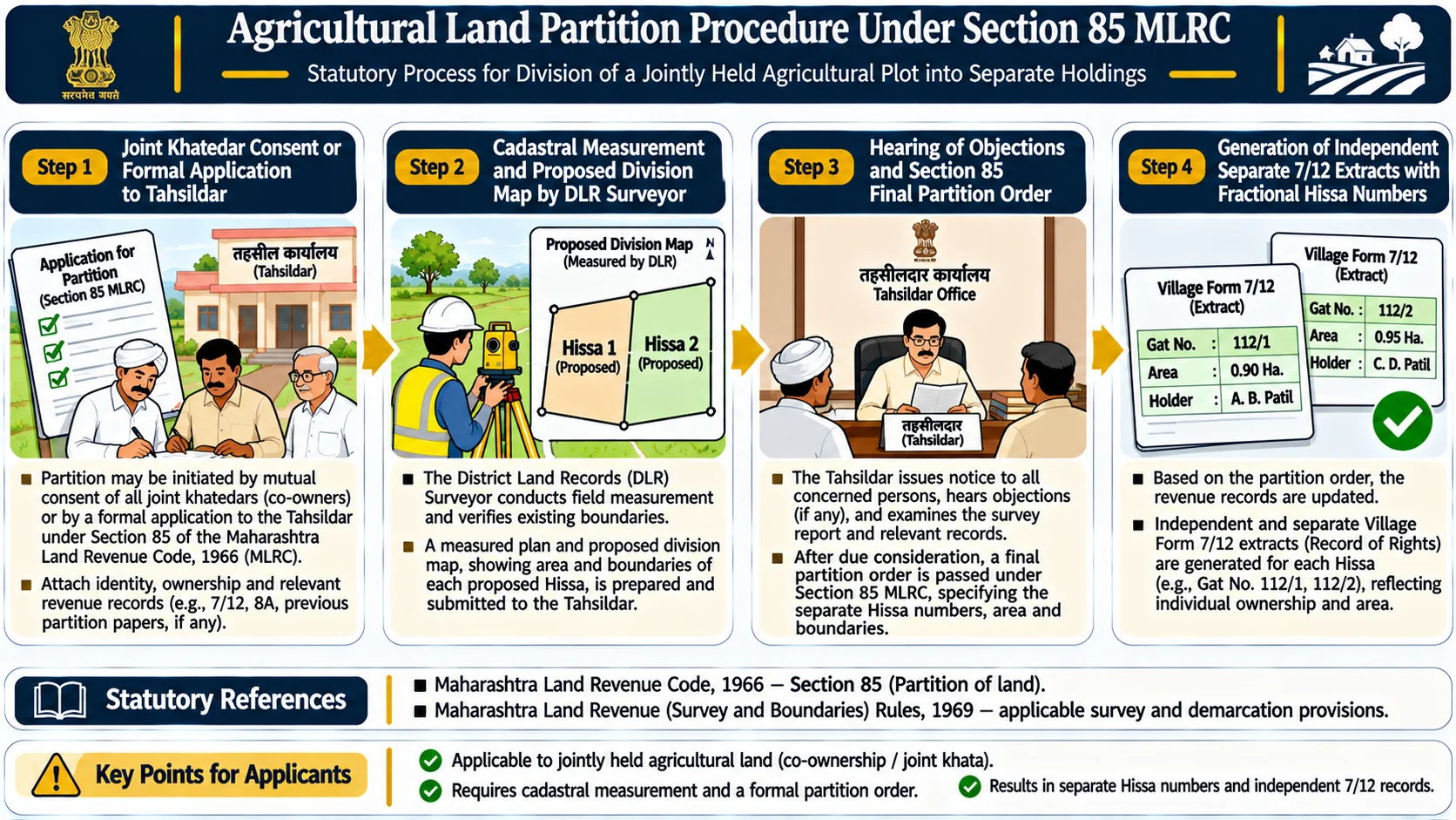
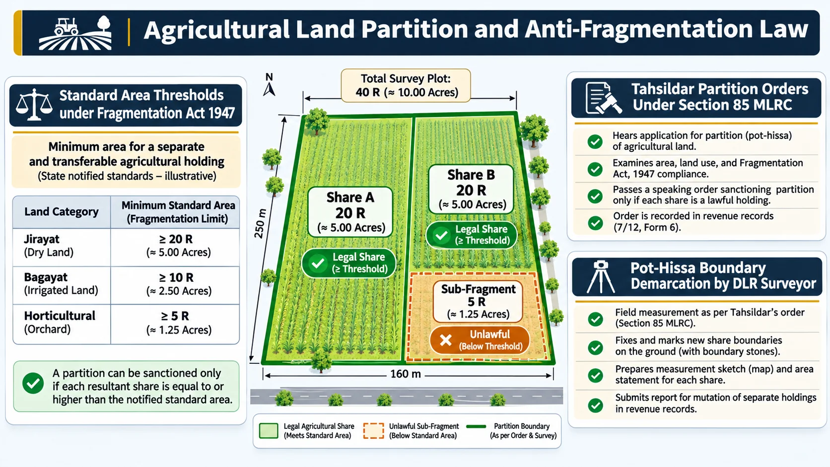
Under Section 85 of the Maharashtra Land Revenue Code, 1966, co-holders of joint agricultural land can apply to the Tahsildar for official partition of their shares. The revenue department demarcates individual hissas and issues separate 7/12 extracts for each co-owner without requiring an expensive civil suit.
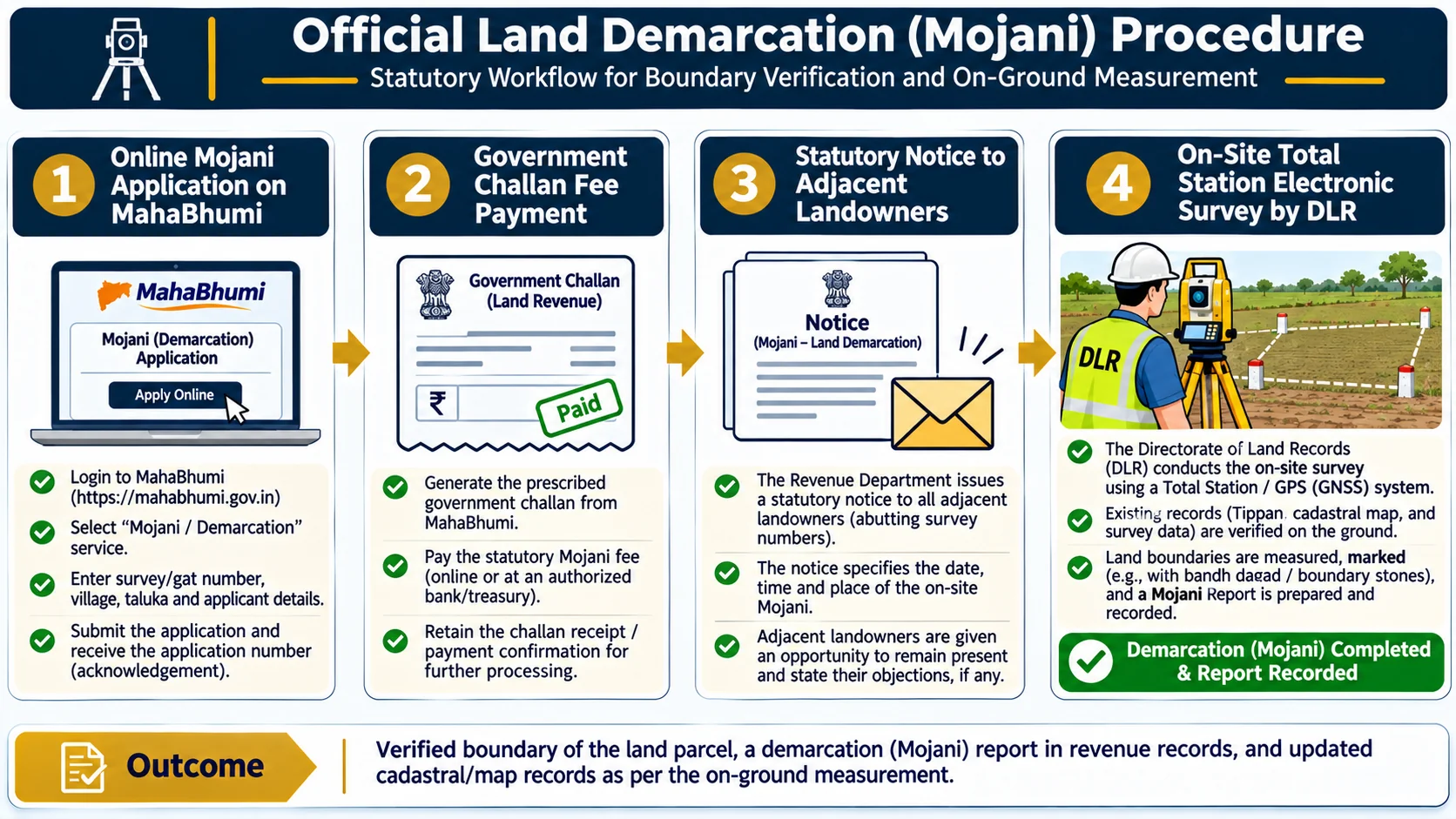
To settle boundary disputes or physically erect cadastral boundary stones, landholders must petition the Taluka Inspector of Land Records (TILR) for official measurement (Mojani). Statutory survey categories comprise:
- Regular Mojani (Sadhi Mojani): Conducted within 60 to 90 days for general partition or verification.
- Urgent Mojani (Tatkal Mojani): Expedited survey completed within 30 days upon payment of higher statutory fees.
- Court Commission Mojani: Demarcation ordered by a Civil Court during boundary adjudication proceedings.
Regional Measurement Standards: Maharashtra vs. Gujarat
| Measurement Unit | Maharashtra Application | Gujarat Application |
|---|---|---|
| Guntha | Universal rural unit (1 Guntha = 1,089 sq. ft. = 1 Are) | Common reference in South Gujarat and Vadodara |
| Acre | Exactly 40 Gunthas (43,560 sq. ft.) | Exactly 40 Gunthas (43,560 sq. ft.) |
| Standard Vigha | Not used in official revenue records | 16 Gunthas (17,424 sq. ft. / 2.5 Vighas = 1 Acre) in Central/North Gujarat |
| Saurashtra Vigha | Not used | 24 Gunthas (26,136 sq. ft. / 1.67 Vighas = 1 Acre) in Saurashtra region |
| Official Cadastral Unit | Hectare - Are - Square Metre | Hectare - Are - Square Metre |
Frequently Asked Questions
How do I read an area recorded as '0.11.90' on a 7/12 extract?
On a 7/12 extract, numbers separated by dots indicate Hectares, Ares, and Square Metres respectively. Therefore, '0.11.90' represents 0 Hectares, 11 Ares, and 90 Square Metres. Because 1 Are equals 1 Guntha, this land measures 11.9 Gunthas (approximately 1,190 square metres or 12,809 square feet).
How many Gunthas are in one Hectare?
One Hectare contains exactly 98.842 Gunthas (100 Ares). Dividing 10,000 square metres by 101.17 square metres gives 98.84 Gunthas. In common conversation, farmers estimate 1 Hectare as roughly 100 Gunthas (2.5 Acres).
How many Gunthas and Square Feet are in one Acre?
One Acre equals exactly 40 Gunthas, which computes to 43,560 square feet (4,046.86 square metres). Each Guntha measures 33 feet by 33 feet (1,089 square feet).
What is the difference between Gujarat Standard Vigha and Saurashtra Vigha?
In mainland Gujarat, a Standard Vigha equals 16 Gunthas (17,424 square feet or 0.40 Acre). In Saurashtra districts, a customary Vigha equals 24 Gunthas (26,136 square feet or 0.60 Acre). Always verify whether an agreement refers to standard or Saurashtra measure.
How does Pot-Kharaba land deduction affect property valuation?
Valuation is calculated strictly on cultivable area (Lagwadi Yogya). Pot-Kharaba Class B (public roads or canals) must be completely excluded from saleable area, while Class A (rocky or barren land) remains privately owned but exempt from land assessment.
What is an Akarband in land revenue records?
The Akarband is the official settlement register prepared during cadastral surveys under Section 105 MLRC. It records total surveyed area, distinguishes cultivable from pot-kharaba land, and fixes the statutory revenue assessment rate.
What is a Tippan and how is it used in Mojani?
A Tippan is the original cadastral survey field book showing boundary baseline lengths and triangulation offsets. Government surveyors use the Tippan to locate buried boundary stones and resolve encroachment disputes.
What is Section 85 partition of agricultural land?
Section 85 of the Maharashtra Land Revenue Code, 1966 empowers the Tahsildar to partition joint ancestral land holdings among legal co-owners, demarking distinct hissas and issuing separate 7/12 extracts without requiring civil litigation.
Official Statutory References & Measurement Manuals
- MahaBhumi Land Records Department: Official portal for Maharashtra revenue surveys, DILR demarcation, and maps.
- Gujarat AnyRoR Revenue Portal: Official repository for Gujarat land records and measurement conversions.
- MahaBhunaksha Cadastral Maps: GIS spatial mapping and survey parcel demarcation service.
- Digital India Land Records Modernization Programme (DILRMP): Technical standards for metric survey conversions.
मराठी अनुवाद (Marathi Translation Notice)
सातबारा उताऱ्यावर क्षेत्रफळ हेक्टर, आर आणि चौरस मीटर (H.R.SqM) या मेट्रिक पद्धतीमध्ये नोंदवलेले असते. १ हेक्टर म्हणजे १०० आर (अंदाजे ९८.८४ गुंठे), तर १ आर म्हणजे १ गुंठा (१०८९ चौरस फूट) होतो. अधिकृत मोजणीसाठी भूमी अभिलेख विभागाच्या (DILR) मोजणी नकाशाचा वापर करावा.
ગુજરાતી અનુવાદ (Gujarati Translation Notice)
જમીન રેકોર્ડ્સમાં ક્ષેત્રફળ હેક્ટર, આર અને ચોરસ મીટરમાં દર્શાવવામાં આવે છે. ૧ હેક્ટર એટલે ૧૦,૦૦૦ ચોરસ મીટર (૧૦૦ આર) થાય છે. ગુજરાતમાં પ્રમાણિત વીઘો ૧૬ ગુંઠા (૧૭,૪૨૪ ચોરસ ફૂટ) નો ગણાય છે, જ્યારે સૌરાષ્ટ્રમાં સ્થાનિક વીઘો ૨૪ ગુંઠાનો હોય છે.