
How to Search a Land Record by Survey Number or Gat Number
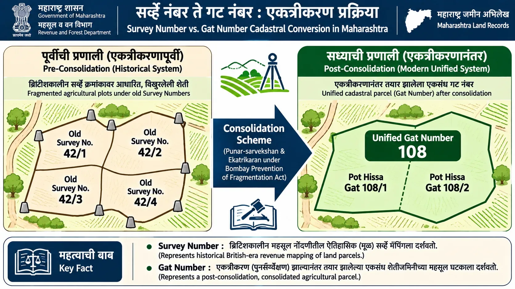
To locate a rural land record, identify the exact state, district, taluka, and revenue village, then search using the cadastral parcel identifier. Maharashtra Mahabhulekh provides direct Survey/Gat Number search. Gujarat AnyRoR provides rural Survey/Block Number lookup. Urban parcels require City Survey (CTS) numbers. Record searches locate fiscal entries; boundary demarcation requires formal cadastral measurement.
Administrative Dimension Fact Sheet: At a Glance
| Item | Verified Specification & Governance |
|---|---|
| Maharashtra Rural Identifier | Survey Number (सर्व्हे नंबर) or Gat Number (गट नंबर), with Hissa (हिस्सा) subdivision numbers. |
| Gujarat Rural Identifier | Survey Number (સર્વે નંબર) or Block Number (બ્લોક નંબર) under Gujarat Land Revenue Rules. |
| Urban Equivalent | City Survey / CTS Number or Malmatta Patrak (Property Card) under Sections 126 and 128 MLRC. |
| Official Portals | Maharashtra: Mahabhulekh Portal | Gujarat: AnyRoR Portal |
| Jurisdiction Lookup | MahaVillages Administrative Portal for Maharashtra revenue jurisdiction. |
| Boundary Evidentiary Standing | Textual 7/12 searches do not determine on-ground boundaries. Physical boundaries require cadastral maps via MahaBhunaksha or Mojani survey. |
1. Identify the Correct Parcel Reference
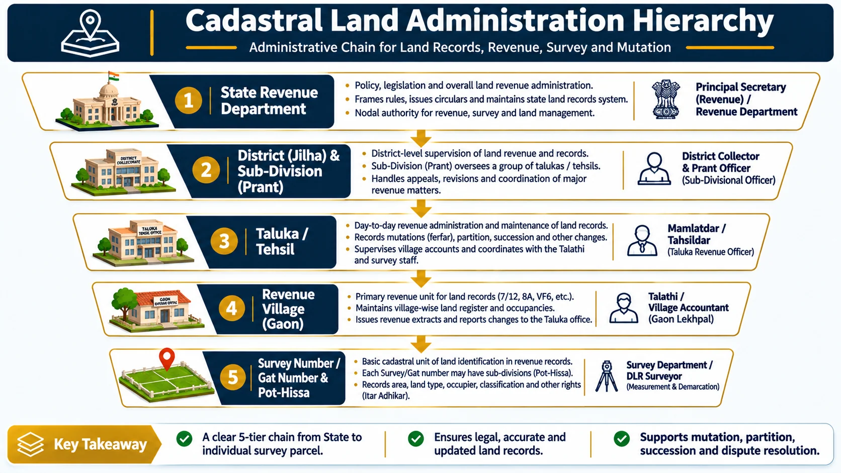
Use the identifier printed on an existing revenue extract, registered conveyance deed, mutation record, or cadastral map. Terminology varies by state and survey system:
- Maharashtra: Survey Number or Gat Number. A parcel may also have a sub-division / Hissa reference (such as 45/2 or Gat 112 Hissa 3).
- Gujarat: Survey Number or Block Number is used in rural records. Check the identifier printed on the extract for that particular village.
- Urban properties: A City Survey / CTS number or property-card reference applies instead of a rural 7/12 identifier.
Do not attempt mathematical conversion or informal conjecture between survey numbers and Gat numbers. Rely exclusively upon the official Gunakar Sheet (correlation register) maintained by the Taluka Inspector of Land Records (TILR).
2. Search by Survey/Gat Number on Maharashtra Mahabhulekh
To conduct an uncertified public inspection on Mahabhulekh:
- Open Mahabhulekh.
- Select the 7/12 record type, if needed.
- Select the District, Taluka, and Village that contain the land.
- Choose Survey/Gat Number (सर्वे नंबर/गट नंबर) in the search options.
- Enter or select the parcel number using the fields and lists displayed by the live portal.
- Complete the on-screen verification and submit. Check the resulting extract against the parcel reference on your existing documents.
3. Search a Gujarat Rural Land Record on AnyRoR
For agricultural land situated in Gujarat:
- Open the Government of Gujarat's AnyRoR @ Anywhere portal.
- Select View Land Record - Rural for a rural parcel. (The portal maintains a separate Urban service for city properties).
- Follow the live form's record-type and location selectors for the relevant District, Taluka, and Village.
- Use the survey or block identifier exactly as recorded in the relevant document and complete on-screen verification.
- Review the returned record and compare its village and parcel details with your source document.
4. If the Portal Returns No Matching Record
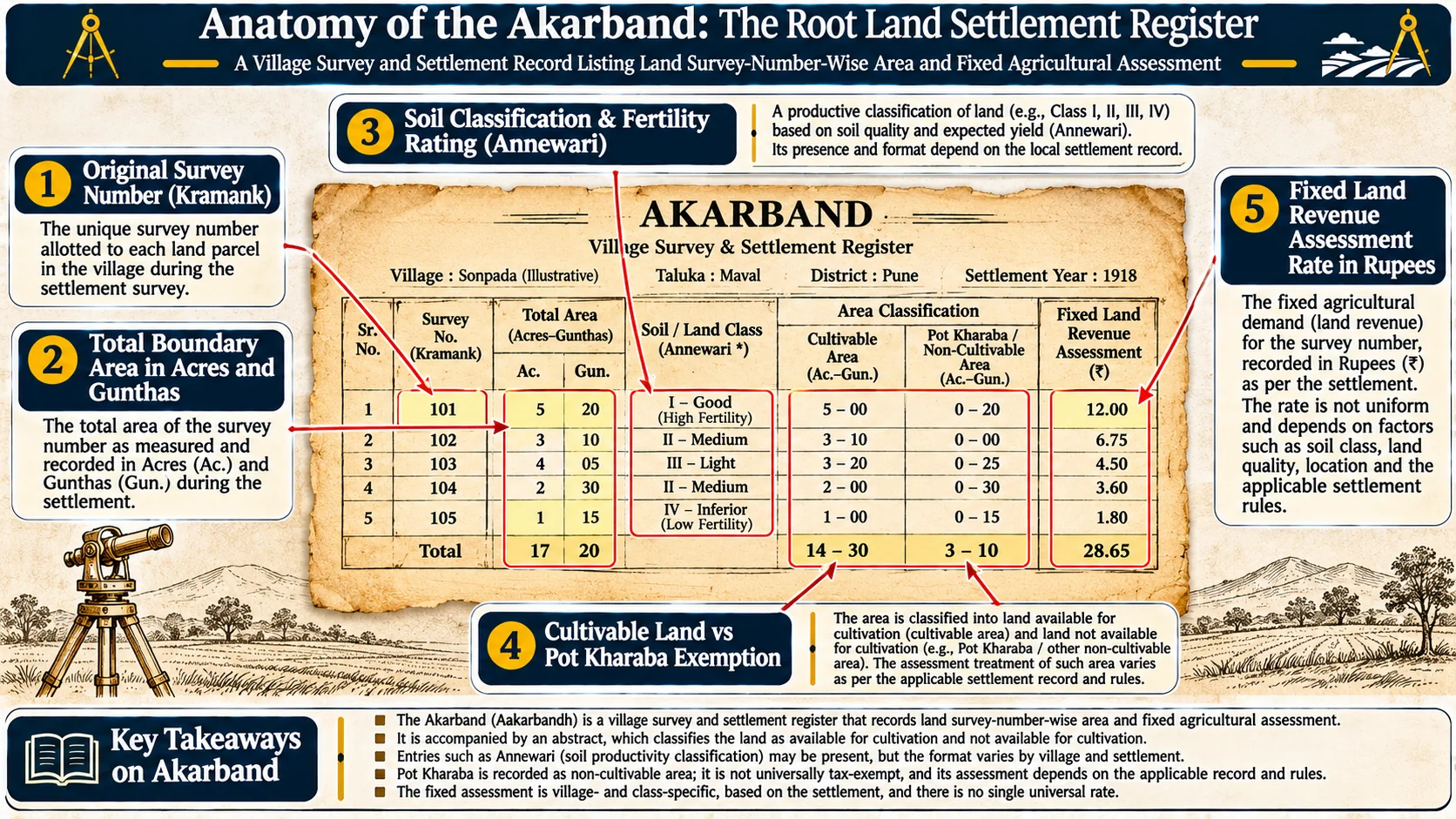
If the revenue portal returns a "Record Not Found" notification:
- Recheck administrative hierarchy: Confirm the district, taluka, and revenue village. A parcel number is not unique across villages.
- Check notation and formatting: Check leading zeroes, suffixes, slash notation, and sub-division details against the source record. Do not remove a suffix unless directed by the portal.
- Verify rural vs urban jurisdiction: Confirm whether the parcel falls under rural revenue records or an urban property-card / City Survey system.
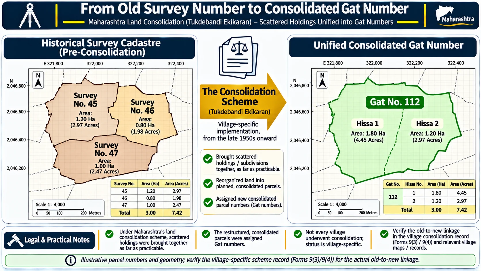
- Check consolidation history: A later mutation, subdivision, consolidation, or re-survey may have altered the parcel reference. Ask the local revenue or survey office for the official correlation (Gunakar Sheet) if old and new identifiers differ.
- Use Maharashtra jurisdiction lookup: Use Maharashtra's Know Your Jurisdiction service to look up jurisdiction using a survey number or village.
5. Survey Number Searches Are Not Boundary Verification
A textual cadastral search retrieves the fiscal revenue ledger corresponding to the specified parcel. It does not establish indefeasible title or delineate physical boundaries on the ground. For boundary verification, inspect official MahaBhunaksha cadastral data and petition the Taluka Inspector of Land Records (TILR) for official measurement (Mojani).
For Maharashtra, see our guide to MahaBhunaksha cadastral maps. For land area metric calculations across Gunthas, Bighas, and Hectares, reference the Land Area Metric Calculator.
Frequently Asked Questions
Is a Gat Number the same as a Survey Number?
Not necessarily. Both identify land parcels in Maharashtra records, but their use depends on the survey and consolidation history of the village. Under land consolidation schemes, older survey numbers were grouped into Gat numbers. Confirm the current identifier from the official record.
What is a Hissa number?
Hissa is a sub-division reference used in land records representing a specific portion of a parent survey or Gat number. Always use the full number shown on the record rather than assuming the parent number alone identifies the parcel.
Can I use a Gujarat Block Number on Maharashtra Mahabhulekh?
No. Use the parcel identifier and portal for the state in which the land is recorded. Gujarat AnyRoR uses Survey/Block numbers, while Maharashtra Mahabhulekh uses Survey/Gat numbers.
What if the old survey number differs from the current record?
Do not guess the new number. Ask the local revenue or survey office for the official correlation register (Gunakar Sheet or Consolidation Register) or updated parcel reference.
Official Sources & Procedural Links
Use government sources directly for official parcel searches and jurisdiction verification:
- Mahabhulekh Live Portal: Mahabhulekh Official Search Portal (Survey/Gat Number and Name options).
- Gujarat AnyRoR Official Portal: AnyRoR Official Portal (Rural and Urban service gateways).
- MahaVillages Jurisdiction Lookup: Know Your Jurisdiction Service.
- Maharashtra Land Records Department: MahaBhumi Gateway.
- Related Procedural Guides: Maharashtra 7/12 Guide, Gujarat AnyRoR Guide, MahaBhunaksha Cadastral Maps, and 7/12 vs Urban Property Card.