
Land Records Statutory Glossary: Maharashtra & Gujarat Revenue Definitions
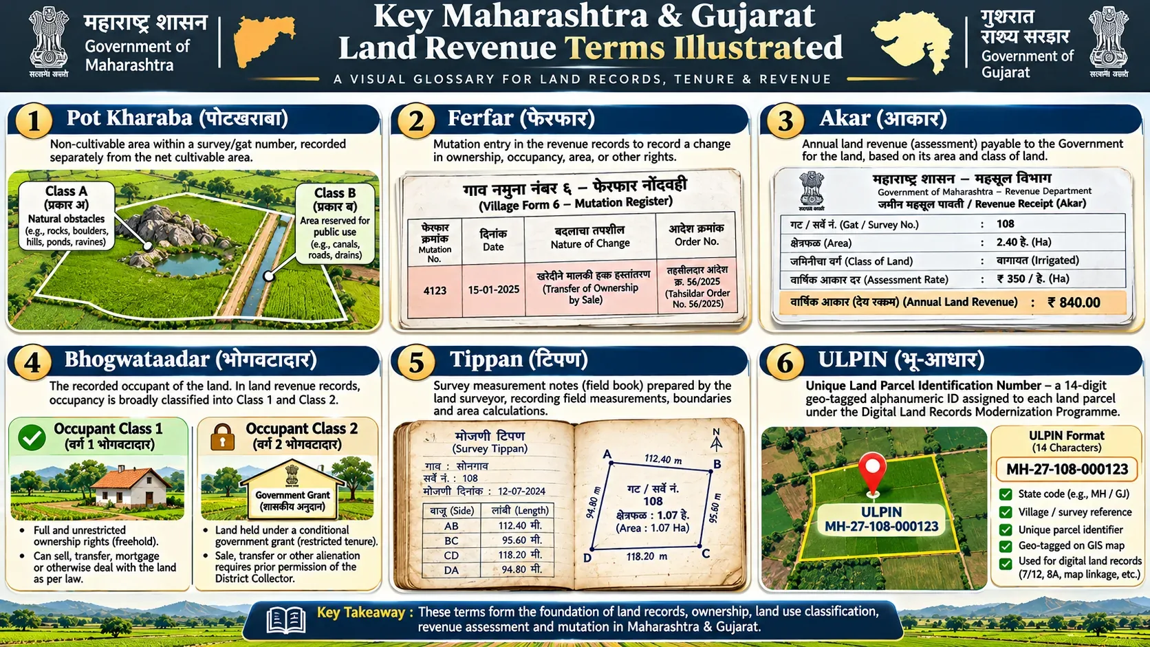
The Land Records Glossary defines statutory revenue terms used in Maharashtra and Gujarat land records under the Maharashtra Land Revenue Code, 1966 and Gujarat Land Revenue Code, 1879. Key terms include 7/12 (Village Forms VII and XII), Ferfar (Village Form VI mutation), 8A Khata, Boja (encumbrance), and ULPIN (Bhu-Aadhaar). Land records serve fiscal revenue purposes and do not confer title.
Administrative Dimension Fact Sheet
| Administrative Dimension | Statutory Specification & Governance |
|---|---|
| Subject Matter | Statutory Land Revenue Terminology (Maharashtra & Gujarat) |
| Governing Codes | Maharashtra Land Revenue Code, 1966 & Gujarat Land Revenue Code, 1879 |
| Primary Record Registers | Village Form VII (Rights), Form XII (Crops), Form VI (Mutations), Form VIII-A (Holdings) |
| Geospatial Standard | Unique Land Parcel Identification Number (ULPIN / Bhu-Aadhaar 14-digit code) |
| Evidentiary Status | Presumption of correctness for fiscal entries; ownership title determined by civil courts |
| Official State Portals | MahaBhumi Portal | AnyRoR Gujarat |
| Last Reviewed | November 2026 |
Understanding Land Revenue Terminology
Land record terminology varies across states, districts, record categories, and historical settlement systems. This glossary provides an objective reference for reading Maharashtra and Gujarat revenue documents. A term appearing on an extract must be interpreted in connection with the governing statute, local administrative format, and underlying official order, rather than from a simplified translation alone.
Common Maharashtra Record Terms
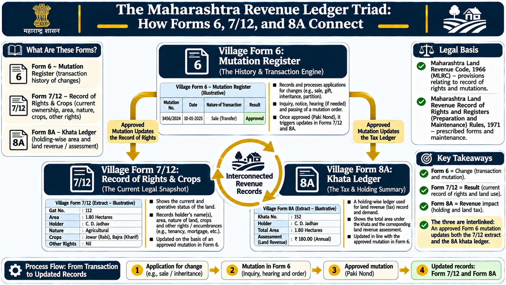
7/12 Extract (Satbara Utara)
A combined administrative extract of Village Forms VII and XII maintained under Section 148 of the Maharashtra Land Revenue Code, 1966. The document pairs the register of rights, occupant details, and tenure particulars with agricultural crop and cultivation data. Official inspection extracts are accessible via Mahabhulekh, while certified digitally signed extracts are issued through DigitalSatbara.
Village Form VII (Rights Register)
The rights portion of the village record. Form VII records names of occupants, tenure classification (such as Bhogvatdar Class 1 or Class 2), total assessment, local cess, government lease terms, and liabilities. Entries carry a statutory presumption of correctness for fiscal purposes under Section 157 of the MLRC, 1966, but do not replace registered instruments of conveyance.
Village Form XII (Pik Pahani / Crop Record)
The agricultural inspection register. Form XII documents season-wise crop cultivation, fallow land, irrigation sources (open well, borewell, canal), and uncultivated areas recorded during field inspections (E-Pik Pahani). This record establishes agricultural use and possession patterns; it is not a title document.
Ferfar / Mutation Register (Village Form VI)
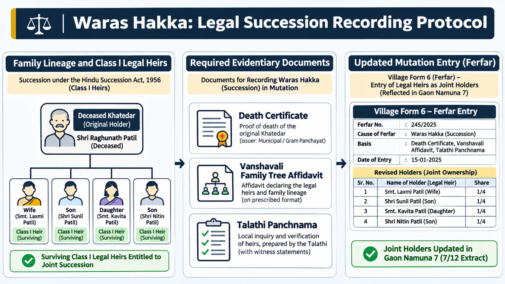
The register of mutations maintained under Section 150 of the MLRC, 1966. Every reported acquisition of right, inheritance, partition, registered sale, mortgage, or court decree is recorded here as an uncertified entry, notified to interested parties, and certified by a Circle Officer after statutory scrutiny. Mutation reflects administrative ledger updates and does not adjudicate disputed civil title.
8A / Khata Extract
The landholder account register. Form 8A lists all agricultural land parcels held by a specific Khatedar (account holder) within a single revenue village, accompanied by the consolidated land revenue assessment. Form 8A is an administrative ledger of holdings; it does not constitute an independent document of title.
Khata / Khata Number
The revenue account identifier assigned to a landholder or joint family within a village. Khata numbers link individual parcels across multiple survey numbers to a single tax assessment account.
Survey Number / Gat Number
The distinct parcel identifier assigned during cadastral survey operations. In consolidated areas, individual survey numbers were consolidated into larger Gat Numbers under the Maharashtra Prevention of Fragmentation and Consolidation of Holdings Act, 1947. Survey numbers and Gat numbers are not universally interchangeable across all talukas; verify the consolidation history.
Hissa Number
The official sub-division identifier indicating a specific share or divided portion within a parent Survey or Gat number. Legal sub-divisions require formal measurement and map promulgation (Pot-Hissa Mojani) by the Land Records Department.
Itar Hakka (Other Rights)
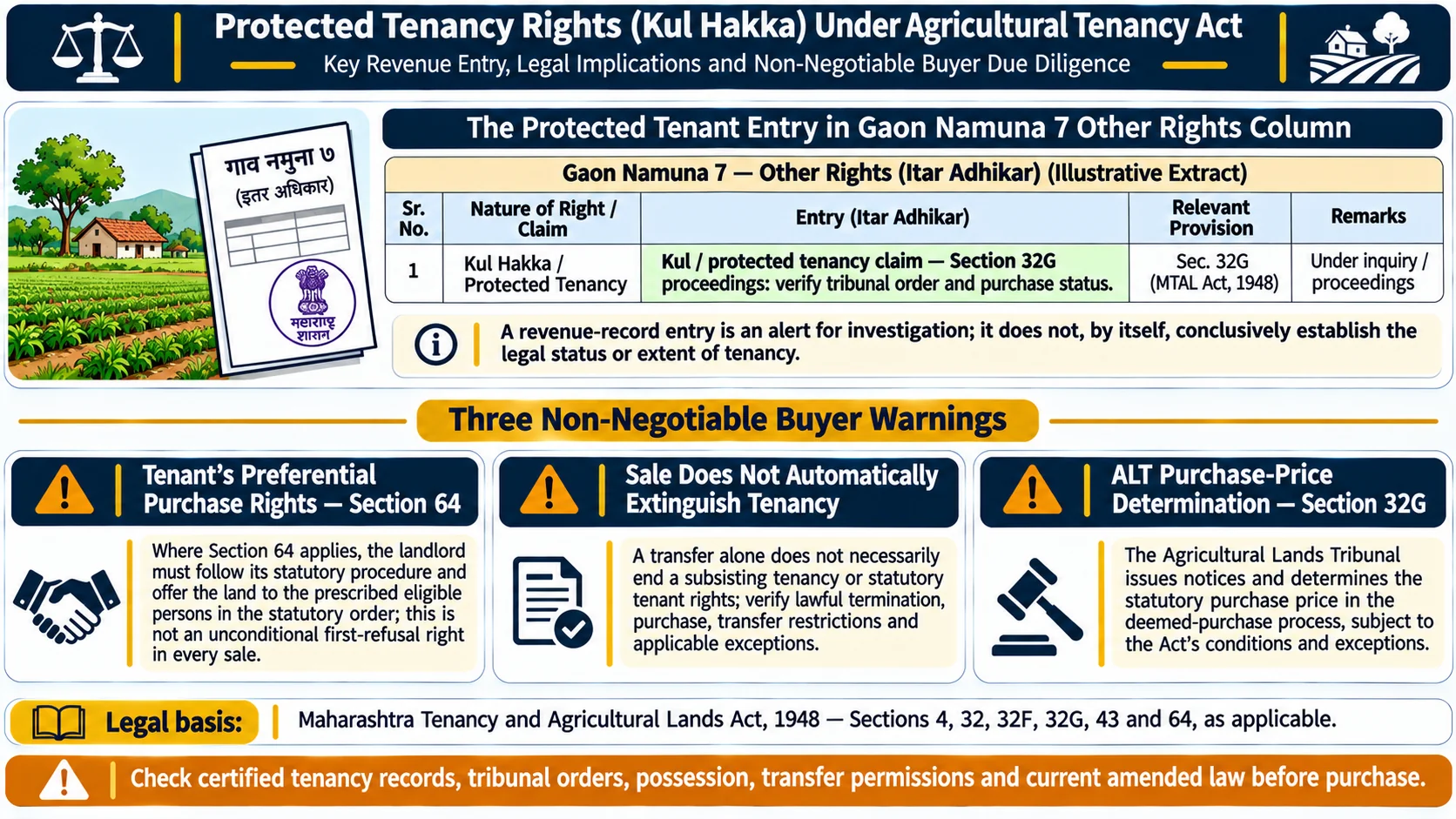
The secondary rights column on Village Form VII. Itar Hakka records encumbrances, bank loan charges (Boja), government dues, tenancy rights under the Tenancy Act, statutory transfer restrictions, or interim injunctions granted by civil courts.
Boja (Mortgage / Charge)
A recorded financial charge or mortgage encumbrance in favor of a lending institution or co-operative society. When a loan is repaid, the encumbrance is not removed automatically; the borrower must obtain a bank release letter (No Objection Certificate) and file a mutation application via e-Hakk charge removal.
Pot-Kharaba (Uncultivable Area)
Land classified as uncultivable or excluded from standard agricultural assessment in survey records. Pot-Kharaba is sub-classified under Land Revenue Rules: Class A consists of land rendered uncultivable by natural features (such as rocks, ravines, and steep slopes), while Class B consists of land reserved for public utilities, village roads, tanks, footpaths, or burial grounds. Classification must be verified from original survey records.
Mojani (Cadastral Survey / Measurement)
An official physical land survey conducted on the ground by Cadastral Surveyors of the Bhumi Abhilekh department. Mojani establishes demarcated physical boundaries, CTS coordinates, and sub-division maps. Viewing an online map on MahaBhunaksha provides orientation but does not substitute for an official Mojani.
Gujarat Terminology: Use State Records Directly
Gujarat land records use distinct statutory terminology under the Gujarat Land Revenue Code, 1879 and e-Dhara administrative manuals. AnyRoR records feature Village Form 7/12, Form 8A, and Village Form 6 (Hakkarak / Mutation). Administrative terms such as Block Number (matching survey numbers in consolidated villages), Promulgation (official gazetting of revised settlement records), and e-Dhara Kendra workflows differ from Maharashtra. Do not assume Maharashtra Ferfar or tenure classifications apply identically across Gujarat.
Occupancy and Tenure Classes: Avoiding Blanket Assumptions
Section 29 of the Maharashtra Land Revenue Code, 1966 categorizes occupants into distinct statutory classes. Whether a parcel is freely transferable depends on its specific grant conditions, tenure category, and applicable special statutes:
- Bhogvatdar Class 1 (Occupant Class 1): Persons holding land with transferable and heritable rights. However, transactions remain subject to statutory limitations, including agricultural land ceiling laws, the Bombay Prevention of Fragmentation and Consolidation of Holdings Act, 1947, and restrictions on transfers to non-tribals under Sections 36 and 36A of the MLRC.
- Bhogvatdar Class 2 (Occupant Class 2): Persons holding land on restricted tenure, including government land grants, tenant allocations under the Tenancy Act, or assigned waste lands. Prior written permission from the District Collector and payment of applicable government premiums (nazrana) are legally required before any sale, gift, mortgage, or lease.
- Government Lessees: Persons holding land under a temporary or long-term lease from the state government under Section 38 of the MLRC, governed strictly by lease covenants and conditions.
Unique Land Parcel Identification Number (ULPIN / Bhu-Aadhaar)
The Unique Land Parcel Identification Number (ULPIN) is a 14-character alphanumeric geospatial identifier developed under the Digital India Land Records Modernization Programme (DILRMP) by the Department of Land Resources (DoLR). It is generated from the longitude and latitude coordinates of parcel vertices. Implementation status varies across states and districts; the presence of an ULPIN does not independently prove civil ownership title.
Procedural Guidelines: How to Read Land Records Safely
- Read the Complete Record: Examine all sections, including occupant particulars, tenure class, assessment figures, and the Itar Hakka column.
- Verify Underlying Instruments: Match recorded entries against registered deeds, mutation orders, probate grants, or partition decrees.
- Separate Viewing from Certified Records: Use viewing portals for preliminary inspection, and obtain certified digitally signed extracts for banking, registration, or judicial submissions.
- Obtain Professional Legal Counsel: For parcel-specific title validation, consult a practicing property advocate and licensed surveyor in the jurisdictional revenue circle.
Frequently Asked Questions
What is the legal difference between Village Form 7 and Village Form 12?
Village Form 7 is the record of rights showing occupants, tenure class, assessment, and encumbrances. Village Form 12 is the crop register showing seasonal cultivation and irrigation. They are combined into the 7/12 extract for administrative convenience.
Does a mutation entry (Ferfar) confer ownership title?
No. The Supreme Court of India in Suraj Bhan v. Financial Commissioner (2007) and Bhimabai Mahadeo Kambekar v. Arthur Import and Export Co. (2019) ruled that mutation entries exist for fiscal revenue purposes and do not create or extinguish civil ownership title.
Can Bhogvatdar Class 2 land be sold without Collector permission?
No. Bhogvatdar Class 2 denotes restricted tenure. It requires prior written sanction from the District Collector and payment of applicable government premiums before any sale, gift, mortgage, or lease.
What is the difference between a Survey Number and a Gat Number?
A Survey Number represents the original cadastral parcel demarcated during land revenue settlement. A Gat Number is a consolidated parcel number created under the Prevention of Fragmentation and Consolidation of Holdings Act, 1947 by grouping multiple survey parcels.